


FURUNO 7" WIDE COLOR LCD GPS/WAAS CHART PLOTTER & FISHFINDER COMBO
Model: GP-1870F
Compact, Powerful GPS Chart Plotter With Fish Finder For Recreational And Fishery Boats
The 7" wide Chart Plotter with fish finder provides the user with powerful, fast performance and intelligent features while remaining compact in size.


Contents:
-
GP-1870F
-
P66 Transducer
Features:
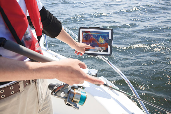
Wirelessly connect to your iOS devices
![]()
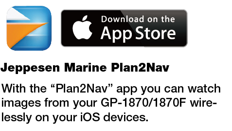
C-Weather information
![]()
* Please visit www.jeppesen.com for further information.
Bright 900 cd/㎡ LCD gives excellent readability even in direct sunlight
The LCD and AR glass are bonded together to ensure no fogging issues.

Our bonded LCDs offer a fog-free structural design. This ensures that the display will never be affected by water condensation, caused by an air gap between the LCD and the front cover plate.
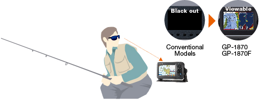
Clear visibility even when wearing polarized sunglasses

The GP-1870 series has an LCD screen that does not “black out” when wearing polarized sunglasses, providing clear visibility from virtualy any angle.
Internal GPS antenna for simple and easy installation

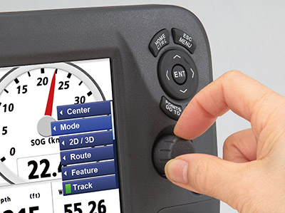
RotoKey™ revolving menu and familiar point-and-click operation
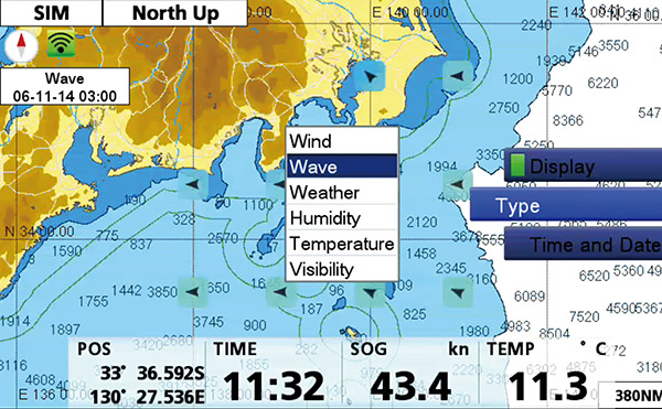
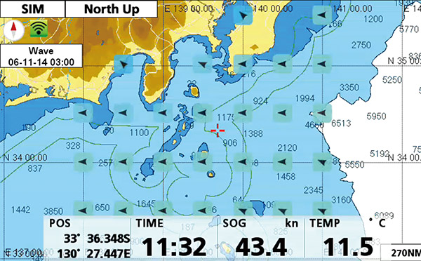
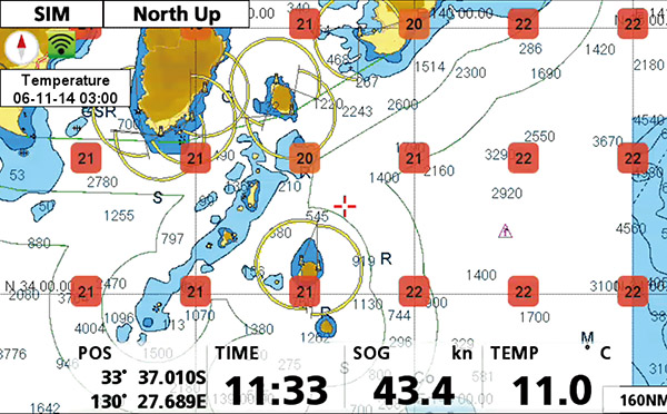
Supports detailed C-MAP 4D charts by Jeppesen (Locally supplied with an SD card)
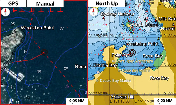
Dual Range Chart Display
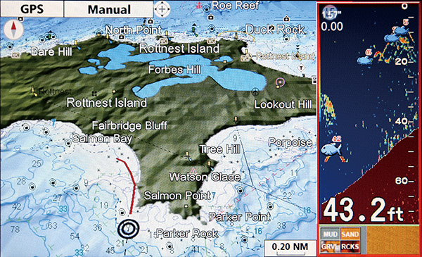
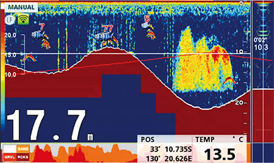
ACCU-FISH & Bottom Discrimination

A unique fish size analyzer, ACCU-FISH indentifies individual fish with size or depth indication and fish symbol. Individual fish size is culculated from echo strength. ACCU-FISHTM can detect the fish size of 10 of 199 cm, in the depth of 2 to 100 m.
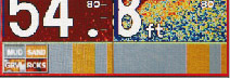
The GP-1870F Bottom Discrimination feature enables the fish finder to indicate if a major component of the bottom is mud, sand, gravel or rocks.
* Thru-hull transom transducer mount required.
Easy-Routing function: Automatically create a route
Internal memory: Waypoint/Track 30,000 points, Route 1,000 routes
White Line function - Discriminates fish lying near the bottom
Easy Replacement from legacy models
Specifications:
Display Unit
| Screen Type | 7" Wide Color TFT LCD |
| Screen Resolution | WVGA 800 x 480 pixels |
| GPS Antenna | Internal (external option) |
| Display Modes | Course plot, Nav Data, Instruments, Engine monitor, Anemometer, Fuel level gauge, GPS status, Fish finder |
| Language | English (US & UK), French, Spanish, German, Italian, Portuguese, Danish, Swedish, Norwegian, Finnish, Greek, Japanese, Chinese, Russian, Thai, Vietnamese, Polish, Bahase Malaysia, Bahasa Indonesia |
GPS / WAAS
| Receiving Type | GPS: 50 channels, WAAS: 1 channel |
| Receiving Frequency | L1 (1575.42 MHz) |
| Accuracy | GPS: 10 m max, MSAS: 7.5 m max |
PLOTTER
| Chart | C-MAP 4D |
| Memory Capacity | 30,000 points for ship's track and wayponts 1,000 planned routes (Max. 50 points per route) 5,000 quickpoints |
FISH FINDER
| Transmit Frequency | 50/200 kHz |
| Transmission | 600 W or 1 kW* * Maching box MB-1100 required. |
| Display Range | 5-1,200 m, shift: 0-500 m |
OTHERS
| Waterproofing | IP56 |
|---|---|
| Power Supply | 12-24 VDC 1.05-0.53 A (Equip 520-5PD) 1,37-0.64 A (Equip 50/200-1T) |
| Size | 168 (H) x 271 (W) x 124 (D) |
| Weight | 1.5 kg |
Transducer P66 :
The P66 TRIDUCER® multisensor features our 50/200 kHz, dual-frequency, single-ceramic element. This hydrodynamic housing with a rounded nose reduces the turbulence under the transducer’s face for accurate high-speed readings and clear display images.
Features:
- Depth, Speed, & Temp
- 50/200 kHz
- 600 W RMS
- Mid-Performance
- Plastic
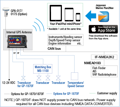
Interconnection Diagram:
Current Reviews: 0
This product was added to our catalog on Tuesday 12 May, 2015.